

THE COURSE
This is the 2025 course description and the 2026 course may change slightly.
The race starts and ends in Rotary Peace Park in downtown Whitehorse. For much of the course, you will be running alongside or above the Yukon River (Chu Níikwän) or one of a few small pothole lakes. The trail, though well used, is worn so watch out for tree roots in many spots. There is significant elevation gain and loss all along the trail.
The course is divided into four legs, ranging in length from 8 to 13 km. The marathon and relay routes consist of all four legs. The half marathon consists of legs 1 and 4.
The trail is well-marked with orange pin markers, flagging tape (usually orange), and sandwich boards at key junctions and road crossings. As well, volunteers are posted at key points to ensure runners remain on course.
The Race Organizing Committee takes steps to make this race as safe as possible for participants and volunteers.
Fluids are available every five kilometers. Gatorade is available at Kwanlin/Miles Canyon (km 8 & km 29.2), the Chadburn Lake day use area (km 19.5), Schwatka Lake (approx. km 32), and the final crossing of Chadburn Lake Road (approx. km 38).
The entire course is located on the traditional territories of the Kwanlin Dün First Nation and Ta'an Kwäch’än Council. All runners are expected to follow Indigenous Yukon’s Respectful Travel Guidelines.
-

Leg 1 - 8 kilometres
A quick start on the Millennium Trail, before a climb on single track to a fantastic view overlooking the river, then dropping down to end at Kwanlin/Miles Canyon.
Photo by Victoria Gadon
-

Leg 2 - 11.5 kilometres
Keep your eyes on the terrain during the technical section through Canyon City. Soon you’ll climb up to gorgeous single track on the Yukon River Trail, overlooking the river.
Photo by William Harris
-
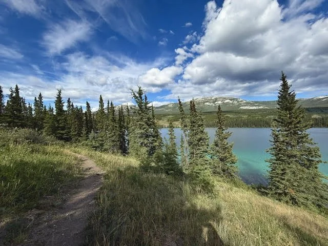
Leg 3 - 9.7 kilometres
A great run along Chadden and Chadburn Lakes, before some challenging hills to get a better view of the lakes and ending with a fun cruise back to Kwanlin/Miles Canyon.
Photo by Paula Gomez Villalba
-

Leg 4 - 13 kilometres
Starting with a flat stretch along Schwatka Lake, the course then takes you through a hilly tour of Hidden Lakes before the home stretch back on the Millennium Trail.
Photo by YRTM
Leg Descriptions
-
Starting at Rotary Peace Park, runners cross under the Robert Campbell Bridge, then immediately take a hard right turn, go up the stairs and onto the bridge before meeting up with the Millennium Trail on the east side of the Yukon River (Chu Níikwän) to the Rotary Centennial Bridge. Cross this foot bridge and follow the trail to the Robert Service Campground, crossing at the parking lot to Robert Service Way. Turn left passing Yukon Energy Corporation's Whitehorse Rapids Plant. Cut left onto Miles Canyon Road and continue to the float plane dock—friendly volunteers meet you at this first water station. A sharp right turn up the embankment brings you onto the trails. Cross the railway tracks and follow the trail for approximately 1.6km, then continue alongside (but not on) Miles Canyon Road for about 50 meters before turning right onto a short narrow section. This takes the runner to the crossing point at the top of the first big hill on Miles Canyon Road. Cross the road and follow the trail which shortly reaches the escarpment, down to the 'saddle' on the east side of the road and a narrow trail that follows Miles Canyon and crosses the single-track bridge before rejoining Miles Canyon Road.
After a short section on the road (100-150 meters), drop down a short, steep trail, and cross the Kwanlin/Miles Canyon Suspension Bridge.Water and Gatorade are available here. This is the first exchange point for the relay. Marathoner runners and leg 2 relay runners turn right (up river). Half marathoners turn left (down river) and follow leg 4 along the east shore of Schwatka Lake.
-
Runners in the marathon and relay events turn right at the bridge (up river) and follow the Yukon River trail through Canyon City.
Extreme caution should be used as there are some steep drop offs to the river in this section. Keep your eyes on the terrain, not the scenery!
Continue along the Yukon River trail for a few kilometres. At the remote aid station, you stay on the Yukon River Trail (do not turn left!) and run for 1km to the turn around point: keep an eye out for signage! When you reach the remote water station for the second time, take a right turn in the direction of Chadburn Lake. Follow a log-strewn trail with a long, steep hill to the Chadburn Lake day use area.Water, Gatorade, and port-a-potties are available here. This is checkpoint 2, the second exchange point for the relay.
-
Continue along Chadburn Lake and follow the trail over to Chadden Lake. The low-lying trail along Chadden Lake is very rooty at times. After a short, steep climb, you’ll continue along rolling hills to the end of the lake where there is a big hill leading to a lookout above the lake—friendly volunteers greet you at this remote water station. Follow the undulating trail for a couple of kilometres before making a sharp left turn up a steep trail to the Chadburn Lake Blue ski trail. Follow the Blue ski trail and cross Chadburn Lake Road. Turn left off the ski trail parking lot and follow the flags back to the Kwanlin/Miles Canyon Suspension Bridge.
This is the checkpoint 3 and the third exchange point for the relay. Water and Gatorade is available here.
-
From the Kwalin/Miles Canyon suspension bridge, the course turns north and follows the east shore of Schwatka Lake past the boat launch and up a short path to the right. The trail continues above the lake and returns to lake level after a few kilometres. Continue through the picnic area where water is available and then take a slight left toward Chadburn Lake Road. After you cross the road, the trail loops around Hidden Lakes (on your left). The trail initially rises, then descends to lake level followed by a steep climb to overlook the lakes. The trail undulates, but stays high before slipping down to the open area before Heart Break Hill (your old friend!). Ascend Heart Break Hill and then enjoy the bone jarring descent to the Chadburn Lake Road—water is available here—and the wheezing climb up the Dam (or is it Damn?) Hill just after crossing the road. Enjoy the awesome view over Schwatka Lake of the green Yukon River (Chu Níikwän) valley and beyond to Mount Lorne and Golden Horn mountain. The trail descends to the river, where you continue on the Millennium Trail, cross the Rotary Centennial Bridge, and continue along the paved trail on the west side of the river, running under the Robert Campbell Bridge and to finish at Rotary Park.
